RCC Disturbance Series: Linear Features
 Published:Apr 27, 2026
Introduction
Since late 2024, the RCC team has been connecting with organizations across the country that are delivering tree-planting and forest-restoration projects with funding from the Government of Canada’s 2 Billion Trees (2BT) Program. These conversations have only reinforced what those doing this work already know: tree planting for restoration takes many forms and often unfolds under diverse, complex, and challenging conditions. While no two tree-planting projects are the same, some contexts require additional layers of planning, coordination, and expertise that extend far beyond the “usual” planting project.
To bring greater visibility and awareness to the unique conditions and challenges of restoring forests after certain disturbances, this article series explores various “non-conventional” restoration project types, such as:
- Linear features restoration
- Post-storm (derecho, hurricanes, and tornados) restoration
- Riparian restoration and bank stabilization
- Post-wildfire forest restoration
Each article will outline the origin, drivers, and scale of the disturbance type, as well as the unique approaches and challenges practitioners must navigate throughout these projects. Each article will also feature case studies showcasing real projects and the organizations leading them.
The intention of these articles is to bring awareness and appreciation to the scale of effort, technical skill, and sustained investment required to restore forested landscapes across Canada, including Indigenous territories. Meaningful forest restoration relies on long-term commitments and partnerships, careful planning, continuous learning, improvement, and adapting to challenging conditions. For practitioners and organizations considering these types of projects, these articles offer practical insights and highlight organizations and communities with on-the-ground experience that may be valuable to connect, collaborate, and exchange knowledge with.
What Are Linear Features?
Linear feature is a general term used to refer to any long, narrow, usually anthropogenic disturbance across the landscape. These include roads, recreational trails, pipelines, seismic (oil and gas exploration) lines, and utility corridors. While these features serve practical purposes for transportation, recreation and industry, these land-use types often come with environmental trade-offs, particularly for the endangered woodland caribou in Canada’s north.
Seismic lines are narrow corridors, typically two to eight metres wide, cut through forests and treed landscapes to allow access for seismic survey equipment used in oil and gas exploration. Although the active use of seismic lines is brief, these corridors can persist for decades. In peatland environments, especially, the disturbed ground, altered hydrology, and compacted soils make forest regeneration slow or effectively impossible without active intervention. Tens of thousands of these lines cut through Western Canada, many cutting through critical woodland caribou habitat.

Legacy seismic lines in Alberta near Richardson Wildland Provincial Park south of Lake Athabasca. Photo: University of Alberta
Scale and Distribution in Canada
Linear features exist across many parts of Canada, but their density and ecological impact vary considerably by region. The highest concentrations of ecologically disruptive linear features are found in the boreal forests of western Canada, particularly in northern Alberta, northeastern British Columbia, and parts of Saskatchewan. [1] This geography overlaps directly with the most extensive oil and gas exploration footprints in the country, as well as with some of the most important remaining woodland caribou habitat on the continent.[2]
The numbers speak to the scale of the challenge. As of 1999, the total length of seismic lines in Alberta alone was estimated at between 1.5 and 1.8 million kilometres.[3] Furthermore, in Alberta’s Boreal Forest Natural Region, conventional seismic lines account for 74% of all linear features—a density of 2.0 kilometres per square kilometre as of 2021.[4] The density of these corridors in some regions is so high that very few patches of forest are left entirely untouched.
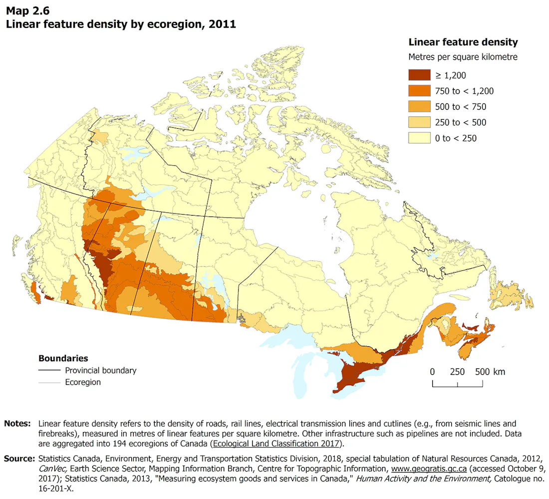
Figure 1. Linear feature density by ecoregion, 2018. Source: Statistics Canada
Reason to Restore: Woodland Caribou
Woodland caribou are found across Canada’s boreal and mountainous regions, ranging from the forests of British Columbia and the Yukon through the Prairie provinces, Ontario and Quebec, and into Newfoundland and Labrador. For many Indigenous Peoples throughout these regions, caribou hold deep cultural, nutritional, and spiritual significance. These animals rely on large, undisturbed tracts of mature boreal forest and peatlands, where they feed primarily on ground and tree lichens. They are listed as threatened or endangered across much of their range, with habitat loss and fragmentation, driven in part by linear features such as seismic lines and roads, as a primary cause of their decline.[5]
How linear features affect forest recovery and vegetation:
Slow and limited natural regeneration. Soil compaction from the equipment used during seismic surveys, combined with hydrological disruption and changes to canopy cover, means that natural vegetation recovery on these features is extremely slow and often insufficient.[6] In peatland settings, passive regeneration may take many decades or more—or may not occur at all without active intervention.[7]
Forest edge effects. Linear features do not only create the corridor in the forest: they alter the forest on either side. The open canopy created by a seismic line changes light, wind, and moisture conditions along the adjacent forest edge, often for tens of metres into the surrounding stand. [8][9] These edge effects can reduce the quality of habitat immediately bordering the line, accelerate drying of peatland soils, promote the establishment of shrubby and disturbance-tolerant vegetation that crowds out lichens, and create conditions that favour other prey species like deer and moose over caribou.[10]
As prey density increases along edges, predators follow—compounding the direct impact of the open corridor on predation risk.[11] In landscapes with high seismic line density, edge effects can affect a substantial proportion of the total forest area, meaning the ecological footprint of linear features extends well beyond what their physical width alone would suggest.[12]
Linear features affect woodland caribou in several interconnected ways:
Habitat fragmentation. Seismic lines and roads break the continuous boreal forest into smaller, isolated patches. Caribou tend to avoid open or disturbed corridors, even narrow ones, because they offer little cover from predators. This forces animals to take longer, less efficient routes between feeding, calving, and refuge habitats, or to confine themselves to increasingly small areas—reducing effective habitat quality even where the forest itself remains intact nearby.[13]
Increased predator access. Bears and wolves travel faster and more efficiently along open linear corridors than through dense forest, effectively extending their range into areas that woodland caribou previously used as low-risk refuges. Research has shown that predation rates on caribou increase significantly in landscapes with high linear feature density.[14]
Restoring Linear Features: Approaches and Challenges
Restoring forest cover along linear features, which are typically extensive and often remote, requires managing additional logistical, economic, and safety challenges, in addition to standard tree-planting challenges such as stock handling, transport, and planting crew deployment. These conditions call for unique approaches to all phases of the project, from planning to planting to monitoring and often require a combination of mechanical, manual, and silvicultural techniques. Some common considerations, approaches, and associated challenges include the following:
Planning and Access
Since many linear features are located on public land and are often used as roads or for recreation, communicating with local communities about the importance and benefits of restoring these features to ensure their cooperation and understanding of the lines they will no longer have access to, and alternative routes that will remain is critical; understanding local use of linear features, for hunting, reaching critical infrastructure, services, or other communities, for example, can offer valuable information that can be incorporated at the project planning stage to limit potential adverse impacts on local communities.
Gathering this information can require holding in-person or virtual consultation meetings with community members or organizations. Likewise, having a strategy to communicate the importance, objectives, and implications for access the project will have to the public is also important; this can be done through a combination of virtual or in-person meetings, written materials, and direct outreach. In addition to community buy-in and communication, physical barriers can prevent motor vehicle access, supporting both public safety and vegetation recovery. Methods may include installing barriers (berms, logs, rocks, gates) or snow fencing. Signage communicating the reasons for restricted access and risks to personal safety and restoration efforts should accompany these barriers.
Planting and Site Treatment
Tree planting is a core active restoration technique on linear features, particularly for legacy seismic lines in peatlands. However, failure rates and costs are significantly higher compared to conventional reforestation.[15] In remote linear corridors, crews may have only one route in and out: returning the same way risks damaging newly planted stock, and helicopter landings are often impossible due to the narrow confines of a seismic line. This often requires ATVs or other specialized equipment, careful operational sequencing, and strong safety protocols. Mortality from soil conditions, competing vegetation, and wildlife browse is common, so multi-year monitoring and follow-up gap planting are often necessary to achieve meaningful canopy closure.[16]
Mechanical Techniques
Tree planting is not the only tool for restoring linear features. Mechanical techniques such as stem bending, hinging (partially cutting a tree so the stem falls across the corridor and remains alive), and hummock transplanting are increasingly used alongside planting.[17]They are often done in the winter months when tree planting is not possible and the frozen ground mitigates impacts on the sensitive ecosystem. Bending or hinging standing vegetation across a corridor immediately reduces open sight lines and discourages predator movement, while hummock transplanting helps rebuild the peatland microtopography that seismic lines destroy. Combined, this functional restoration and habitat restoration address the ecological problem at two timescales: reducing predator access in the near-term while planted trees grow toward canopy closure.[18]
Monitoring and Maintenance
Because natural regeneration on linear features is slow and planting success is unpredictable, monitoring is an ongoing commitment that extends for years or decades after initial treatment.[19] Monitoring helps practitioners identify gaps, assess whether the restoration activities are functioning as intended, and adapt treatments based on results. Drones and satellite imagery are increasingly used to reduce monitoring costs in remote terrain, but ground-truthing remains essential.[20]

Graphical abstract from Dickie et al. (2022).[22]
Who Is Doing This Work
Although linear feature restoration is occurring across Canada, most active projects are concentrated in the western boreal forest, particularly in regions where seismic line density is highest and where woodland caribou populations are most at risk. Alberta, home to the greatest density of seismic lines in the country, is the epicentre of these efforts.[21] Northeastern British Columbia, with its own extensive oil and gas exploration footprint, is another focal area. Saskatchewan, as highlighted in the case study accompanying this article, is building a program that addresses legacy features in the province’s western boreal region within the SK2 Caribou Conservation Area.

Figure 2: Seismic line restoration trends in Alberta. Figures for 2025 are estimates. Data: Government of Alberta
Other organizations and programs active in this space:
Caribou Habitat Restoration Fund (CHRF), delivered through the Habitat Conservation Trust Foundation.
Boreal Ecosystem Recovery and Assessment (BERA), a multi-sectoral partnership focused on understanding the effects of industrial disturbance on natural ecosystem dynamics.
Caribou Habitat Recovery Program, supporting on-the-ground restoration in caribou range across the western boreal
Reclaimit, a restoration contractor with significant experience in linear feature and seismic line restoration in Alberta.
Blueberry River First Nations (B.C.), whose community-led crews are undertaking a nine-year plan to restore over 900 km of linear features (4,000 ha) across its territory.
Aski Reclamation LP (B.C.): Revegetated 31 linear kilometres of legacy seismic line disturbance using eco-cultural restoration techniques through the BC Oil and Gas Research and Innovation Society PNG Legacy Site Groundbirch Restoration Program in 2022.
The Forest Resource Improvement Association of Alberta (FRIAA) via its Caribou Habitat Recovery Program
Seismic lines aren’t the only linear features requiring broad restoration efforts. Old forestry roads, pipeline corridors, and recreational trails also fragment the landscape. Williams Lake First Nation in southern B.C., for example, is decommissioning and restoring old cutblock roads to limit predator access and sightlines. The RCC profiled its program in its Reclaiming the Land case study.
Conclusion
What makes linear-feature restoration particularly demanding is that success requires more than planting trees. It often requires restoring hydrology, rebuilding soil quality, managing access, engaging communities, and monitoring outcomes over time frames that far exceed the typical project funding cycle.
From a practical standpoint, it involves navigating remote and difficult terrain, deploying specialized equipment, and adapting techniques to the challenges of narrow corridors through peat bogs and boreal wetlands. Critically, it requires sustained funding and partnerships—the kind of long-term commitment that allows organizations to learn from early projects, refine their approaches, and build the systemic knowledge this work depends on.
The organizations and communities profiled in the accompanying case studies represent two distinct but complementary models for how that commitment can take shape.
Saskatchewan's Ministry of Environment is in the early stages of building a program from the ground up, navigating site assessment, stakeholder engagement, operational planning, and contractor procurement before a single tree goes in the ground.
The challenge now is ensuring that the investment, policy support, and cross-sector collaboration required to meet the scale of the problem keeps pace with the urgency of the need, particularly as the 2BT program winds down.
Want to learn more about linear feature restoration?
Check out the resources hosted on the Canadian Conservation and Land Management portal!
Sustained Investment in Forest Recovery
In 2021, the Government of Canada launched the 2BT program, a $3.2 billion, ten-year initiative to plant two billion trees across Canada by 2031 in partnership with provinces, territories, Indigenous governments municipalities, and non-profits. Funded under the federal Natural Climate Solutions Fund, the 2BT program was designed as a long-term initiative supporting tree planting across public, private, urban, and Indigenous lands, as well as restoration-focused projects. On November 4, 2025, the Government announced that the program would wind down. Existing agreements will be honoured, but no new applications are being accepted.
By June 2025, the 2BT program had commitments for 988 million trees, with over 228 million already planted, agreements in place with 11 of 13 provinces and territories, and projects spanning more than 300 species. Furthermore, 26% of all 2BT projects are Indigenous-led.
There remains an urgent and growing need for continued, long-term investment in forest recovery across the country. Forests play a vital role in community health and safety, climate adaptation and mitigation, biodiversity conservation and recovery, and the and the forest recovery systems is an important driver of skilled rural employment. It can also reinforce and enable Indigenous-led conservation and cultural revitalization.
If you or your organization would like to learn more about how long-term, sustainable investment supports Canada’s forest recovery system and explore opportunities to engage with others working in this space, feel free to reach out to hello@reforestcollective.ca. We’re always happy to connect and continue the conversation.
Citations
[1] Statistics Canada. 2018. Linear Feature Density [map], 194 ecoregions. Energy and Transportation Statistics Division. Based on Natural Resources Canada CanVec data, 2012, and Statistics Canada, Human Activity and the Environment, Cat. no. 16-201-X, 2013.
[2] Nessbit, L.M., et al. 2016. “Billion dollar boreal woodland caribou and the biodiversity impacts of the global oil and gas industry.” Biological Conservation 206: 102–111.
[3] Environment and Climate Change Canada. 2020. Recovery Strategy for the Woodland Caribou (Rangifer tarandus caribou), Boreal Population, in Canada [Amended]. Species at Risk Public Registry. https://www.canada.ca/en/environment-climate-change/services/species-risk-public-registry/recovery-strategies/woodland-caribou-boreal-2020.html
[4] Alberta Biodiversity Monitoring Institute (ABMI). 2023. Status of Human Footprint in the Boreal Forest Natural Region, circa 2021. https://archive.abmi.ca/home/reports/2023/human-footprint/details.html?id=8
[5]Environment and Climate Change Canada. 2020. Amended Recovery Strategy for the Woodland Caribou (Rangifer tarandus caribou), Boreal Population, in Canada. Species at Risk Act Recovery Strategy Series. Ottawa. https://www.canada.ca/en/environment-climate-change/services/species-risk-public-registry/recovery-strategies/woodland-caribou-boreal-2020.html
[6] Dabros, A., Pyper, M., and Castilla, G. 2018. “Seismic lines in the boreal and arctic ecosystems of North America: environmental impacts, challenges, and opportunities.” Environmental Reviews 26(2): 214–229.
[7] van Rensen, C.K., et al. 2015. “Natural regeneration of forest vegetation on legacy seismic lines in boreal habitats in Alberta’s oil sands region.” Biological Conservation 184: 127–135.
[8] Stern, E.R., Riva, F., and Nielsen, S.E. 2018. “Effects of narrow linear disturbances on light and wind patterns in fragmented boreal forests in northeastern Alberta.” Forests 9(8): 486.
[9] Dabros, A., James Hammond, H.E., Pinzon, J., Pinno, B., and Langor, D. 2017. “Edge influence of low-impact seismic lines for oil exploration on upland forest vegetation in northern Alberta (Canada).” Forest Ecology and Management 400: 278–288.
[10] Finnegan, L., MacNearney, D., and Pigeon, K.E. 2018. “Divergent patterns of understory forage growth after seismic line exploration: implications for caribou habitat restoration.” Forest Ecology and Management 409: 634–652.
[11] Dickie, M., Serrouya, R., McNay, R.S., and Boutin, S. 2017. “Faster and farther: wolf movement on linear features and implications for hunting behaviour.” Journal of Applied Ecology 54(1): 253–263.
[12] Van Dongen, A., Jones, C., Schoonmaker, A., Harvey, J., and Degenhardt, D. 2023. “The influence of forest harvesting activities on seismic line tree and shrub regeneration in upland mixedwood boreal forests.” Canadian Journal of Forest Research 53(11): 855–877.
[13] DeMars, C.A., and Boutin, S. 2018. “Nowhere to hide: effects of linear features on predator-prey dynamics in a large mammal system.” Journal of Animal Ecology 87(1): 274–284.
[14] Dickie, M., Serrouya, R., McNay, R.S., and Boutin, S. 2017. “Faster and farther: wolf movement on linear features and implications for hunting behaviour.” Journal of Applied Ecology 54(1): 253–263.
[15] Filicetti, A.T., Cody, M., and Nielsen, S.E. 2019. “Caribou conservation: Restoring trees on seismic lines in Alberta, Canada.” Forests 10(2): 185. https://doi.org/10.3390/f10020185
[16] Dabros, A., Pyper, M., and Castilla, G. 2018. “Seismic lines in the boreal and arctic ecosystems of North America: environmental impacts, challenges, and opportunities.” Environmental Reviews 26(2): 214–229.
[17] Environment and Climate Change Canada. 2015. Defining Habitat Restoration of Boreal Caribou: Discussion Paper. Canada.ca.
[18] Dabros, A., Pyper, M., and Castilla, G. 2018. “Seismic lines in the boreal and arctic ecosystems of North America: environmental impacts, challenges, and opportunities.” Environmental Reviews 26(2): 214–229. (citing Pyper et al. 2014)
[19] Government of Alberta. 2024. Caribou Habitat Recovery Program. alberta.ca.
[20] Chen, S., et al. 2017. “Measuring Vegetation Height in Linear Disturbances in the Boreal Forest with UAV Photogrammetry.” Remote Sensing 9(12): 1257; Doucet, C., et al. 2022. “Ground Validation of Seismic Line Forest Regeneration Assessments Based on Visual Interpretation of Satellite Imagery.” Forests 13(7): 1022.
[21]Dabros, A., Pyper, M., and Castilla, G. 2018. “Seismic lines in the boreal and arctic ecosystems of North America: environmental impacts, challenges, and opportunities.” Environmental Reviews 26(2): 214–229.
[22] Dickie, M., Sherman, G. G., Sutherland, G. D., McNay, R. S., & Cody, M. 2023. "Evaluating the impact of caribou habitat restoration on predator and prey movement." Conservation Biology 37(14004). https://doi.org/10.1111/cobi.14004
Related Articles
Understanding Landholder Motivations
Article authored by the Agroforestry & Woodlot Extension Society on the topic of navigating landowner motivations for a tree planting project
See Resource
Restoring forest cover at diverse sites across Canada can balance synergies and trade-offs
Mapped restoration scenarios that prioritize different objectives to amplify synergies and characterize solutions to trade-offs
See Resource

Climate Smart Forestry: Expert Panel on Adaptive Strategies for Diverse Management Objectives
Document summarizing climate adaptation strategies, approaches, and tactics relevant to New Brunswick’s forests
See Resource

NHRI Adaptive Silviculture Volume 1
Guidebook on the appopaches of adaptive silviculture and climate-smart forestry in New Brunswick
See Resource

